Dubai Metro Map Overview
For 2025–2026, the practical Dubai Metro map shows operational Red and Green routes, plus future Blue and Gold corridors. The Red Line runs from the airport side toward Jebel Ali, UAE Exchange and the Expo route, while the Green Line runs from Etisalat by e& to Creek.
On a good map, operational lines should be solid, while planned routes like the Blue Line and Gold Line should appear dotted or faded. Interchange stations matter most: Union and BurJuman are the main transfer points between Red and Green lines.
The Dubai Metro operates across 47 stations on two main lines, covering a total network of 74.6 kilometers. The Red and Green lines form the backbone of public transport in Dubai.
Latest Network Map
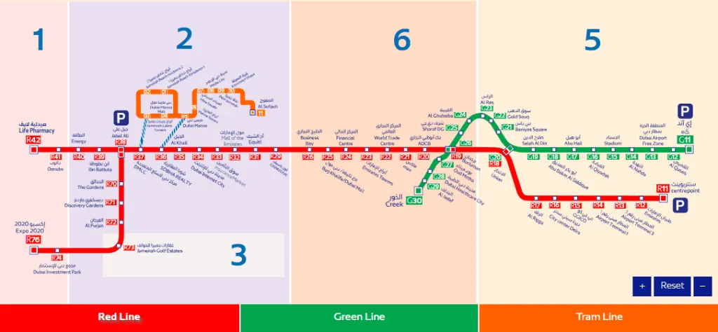
Operational Red and Green lines with future extensions clearly marked.
Red Line: Airport to Dubai Marina & Beyond
The Red Line is 52.1 kilometers long and connects major areas including Dubai Airport, Business Bay, Downtown Dubai, and Dubai Marina. It serves key locations like Burj Khalifa, Dubai Mall, and Jebel Ali.
| Direction | Useful Stops |
|---|---|
| Airport Corridor | Centrepoint, Airport T3, Airport T1, Deira City Centre |
| Central Dubai | Union, BurJuman, Emirates Towers, Burj Khalifa/Dubai Mall |
| South-west Dubai | Mall of the Emirates, Sobha Realty, DMCC, Expo City Dubai |
A typical airport-to-Downtown journey takes around 25–35 minutes, while Burj Khalifa to Dubai Marina can take roughly 30–40 minutes depending on station choice and transfers.
Green Line: Historic Dubai & Creek
The Green Line runs from Etisalat by e& (Al Qusais) to Creek station, looping around Dubai Creek. It is the best line for old souks, creek crossings, heritage lanes and budget shopping areas.
Historic Hubs
Al Ras (Gold Souk), Al Ghubaiba (Marine Hub), Al Fahidi (Heritage).
Key Transfers
Union and BurJuman connect to the Red Line for modern Dubai access.
Future Blue Line & Proposed Gold Line
Dubai is continuing to expand the network. The upcoming Blue Line, expected to open in 2029, will span 30 kilometers and include 14 new stations, connecting areas like Dubai Creek Harbour and Academic City.
The proposed Gold Line is planned as a 42km network (opening 2032), connecting 15 strategic locations including Mina Rashid, City Walk, and Mohammed Bin Rashid City.
The Blue Line will improve access to International City and other fast-growing districts. Check official RTA announcements for final station names.
Key Metro Stations & Popular Areas
Burj Khalifa / Dubai Mall
Dubai Marina (DMCC/Sobha)
Fares, Zones & Nol Card
Fares are zone-based. Dubai is divided into 7 zones total for public transport. Tapping in and out with a Nol Card is mandatory.
Accessibility & Facilities
All Dubai Metro stations are fully wheelchair accessible, featuring elevators, tactile flooring, and dedicated spaces for wheelchair users on trains. "People of Determination" can travel for free with a special personalized Nol Card.
- Wi-Fi on the move
- 3000+ CCTV Security
- Dedicated Metro Police
- Emergency Call Boxes